
Kudremukh also spelled Kuduremukha is a mountain range and name of a peak located in Chikkamagaluru district, in Karnataka, India. It is also the name of a small hill station cum mining town situated near the mountain, about 48 kilometres from Karkala and around 20 kilometres from Kalasa. The name Kuduremukha literally means 'horse-face' (in the Kannada language) and refers to a particular picturesque view of a side of the mountain that resembles a horse's face. It was also referred to as 'Samseparvata', historically since it was approached from Samse village. Kuduremukh is Karnataka's 3rd highest peak after Mullayangiri and Baba Budangiri. The nearest airport is Mangalore International Airport at Mangalore which is at distance of 130 kilometres.
Ecology
The wet climate and the tremendous water retentive capacity of the shola grasslands and forests have led to the formation of thousands of perennial streams in the region converging to form three major rivers of the region A diverse assemblage of endangered large mammals is found in the park supporting three large mammal predator species such as the Tiger, Leopard and Wild Dog. The important Tiger prey base found within the Park is Gaur, Sambar, Wild Pig, Muntjac, Chevrotain, Bonnet Macaque, Common Langur and the Lion-tailed Macaque
Location
The Kudremukh National Park (latitude 13°01'00" to 13°29'17" N, longitude 75°00'55' to 75°25'00" E) is the second largest Wildlife Protected Area belonging to a tropical wet evergreen type of forest in the Western Ghats. Kudremukh National Park is located in Dakshina Kannada, Udupi District and Chikkamagaluru districts of the State of Karnataka. The Western Ghats is one of the thirty four hotspots identified for bio-diversity conservation in the world. Kudremukh National Park comes under the Global Tiger Conservation Priority-I, under the format developed jointly by the Wildlife Conservation Society (WCS) and World Wide Fund-USA...
History
Well known environmentalist and Tiger expert Dr. Ullas Karanth, undertook a detailed and systematic survey of the distribution of the endangered Lion-tailed Macaque in Karnataka during 1983-84 with support from the Government of Karnataka. He observed that suitable and extensive rain forest habitat for the Lion-tailed Macaque existed in Kudremukh and that the tract probably harboured the largest contiguous population of Lion-tailed Macaques in the Western Ghats, outside the Malabar region. He further suggested that Lion-tailed Macaques could be effectively used as a 'flagship' species to conserve the entire biotic community in the region and prepared a conservation plan for the survival of wild populations of Lion-tailed Macaques in the region delineating the present national park area as a proposed nature reserve. Based on his report, the Karnataka State Wildlife Advisory Board suggested to the Government that Kudremukh National Park be created. Subsequently, in 1987, the Government of Karnataka declared these Reserved Forests as a National Park based on the above suggestion.
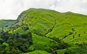
Kudremukh National Park is spread partly over the thick hilly forests near the coastal plains on the western portion and the shola vegetation on the Western Ghats uplands, covering parts of three districts, viz., Chickmagalur, Udupi and Dakshina Kannada. The Kudremukh peak, by which the national park derives its name, is the highest spot at 1892 meters. The hills, which bear the brunt of the severe monsoon winds, preclude any tree growth added to that the region is known for its rich low grade magnetite soil which primarily inhibits plant growth. As a result, the landscape is covered with grass. The valleys which are tucked in, have reasonable protection from wind and a deep soil profile, as a result of which stunted evergreen forests exist creating a unique micro climate, rich with mosses, orchids, etc. The whole scenery of grassland interspersed with narrow strips of forests provides a fantastic vista..
Three important rivers, the Tunga, the Bhadra and the Nethravathi are said to have their origin here. A shrine of goddess Bhagavathi and a Varaha image, 1.8 m within a cave are the main attractions. The Tunga River and Bhadra River flow freely through the parklands..


.jpg)

No comments:
Post a Comment